
Laser scanning can capture an enormous amount of accurate information about an existing building, factory or process plant. But getting the most value from a survey starts before the first scan is taken.
Understanding how the information will be used helps determine what needs to be captured, where greater detail or coverage may be important, and which deliverables will best support the project. It also helps avoid spending survey and processing time capturing or modelling information that provides little value.
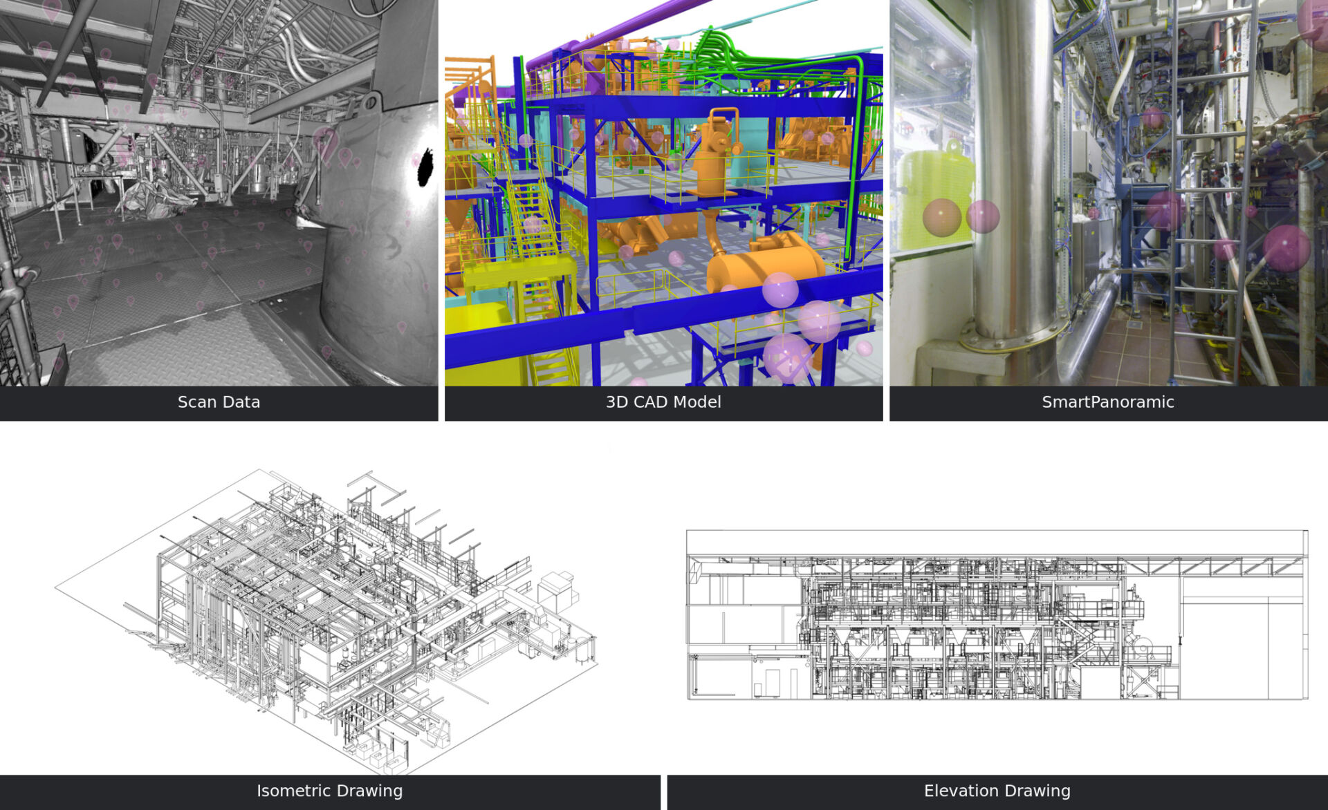
For some projects, a registered point cloud may be all that is required. Others benefit from a purpose-built 3D CAD model, while in many cases conventional drawings remain the most useful deliverable. Visual access to the survey can also be valuable for people who don’t routinely work with point clouds or CAD.
There isn’t a single correct answer. The right deliverables depend on how the survey will be used, how the project is expected to develop and, ideally, whether the information could have value beyond the immediate requirement.
The point cloud is often a useful starting point
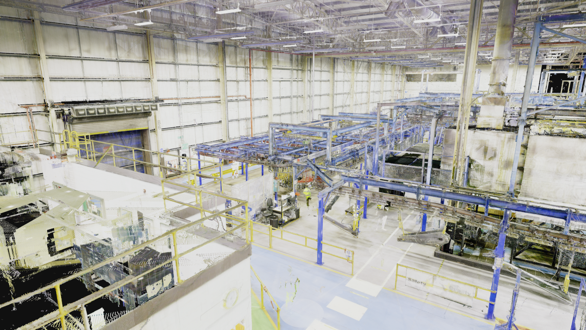
A registered point cloud provides an accurate three-dimensional record of the surfaces captured during the laser scanning survey.
For engineers equipped to work with point-cloud data, it can be used directly within the design process. Proposed equipment, structures and pipework can be positioned against the surveyed environment, dimensions can be checked and potential clashes with existing plant can be investigated.
This can make a point-cloud-only approach particularly attractive to contractors. If the immediate requirement is to design and install a particular piece of equipment, the contractor may have little need for a model of the existing facility once their project is complete.
In that situation, converting everything captured by the scanner into CAD geometry may add cost without necessarily adding equivalent value to the project.
Point clouds during FEED and early design
Point clouds can also be particularly useful during Front-End Engineering Design (FEED) and other early design stages.
At this point, engineers may still be evaluating different options. They need reliable information about existing site conditions to understand constraints, investigate layouts, consider tie-in locations and determine whether proposed equipment can be accommodated.
A detailed model of the complete existing facility may not yet be necessary.
Instead, the point cloud can provide the existing-condition reference while different design options are developed. Specific structures, interfaces or areas of plant can then be modelled where usable CAD geometry is required.
This also avoids investing significant modelling effort before the eventual scope of the project is known.

When does a 3D CAD model add value?
Although working directly with a point cloud can be very effective, an as-built CAD model provides something different.
It converts the measured survey data into clean, structured geometry that is generally easier to interrogate and incorporate into an engineering design workflow. Individual objects and surfaces can be selected, isolated and used directly as references for new design geometry.
A model can also have a useful life well beyond the project that originally commissioned the survey.
The same as-built information might subsequently support plant modifications, equipment replacement, layout planning, access studies, maintenance activities or future engineering projects.
This is where the business case can become broader than the requirements of an individual project.
A contractor may quite reasonably only need a point cloud to complete their work. For the asset owner, however, an appropriate as-built model could continue to provide value to other engineering teams long after that particular project has finished.
But modelling everything isn't always the answer
The fact that a model has potential long-term value doesn’t mean that every item captured by a laser scanner should automatically be modelled.
Creating an as-built CAD model requires time and engineering judgement. The modeller has to determine what should be represented, the appropriate level of detail and how real-world surfaces and components should be interpreted as CAD geometry.
There is little value in spending time producing detailed models of objects that aren’t relevant to the intended application.
This becomes particularly obvious on modification and brownfield projects. If a significant section of existing plant is scheduled for demolition, producing a highly detailed model of equipment that may no longer exist in six months is unlikely to represent good value.
A better approach may be to model the structures, equipment and interfaces that will remain, while retaining the point cloud as the complete record of the surveyed area.
Sometimes a drawing is all that's needed
It is also easy to overlook the continuing usefulness of conventional 2D information.
A floor plan, elevation or section derived from laser scan data may be far more useful to some people than either a large point-cloud dataset or a detailed 3D model.
For building layouts, space planning, site records and many engineering activities, a well-produced drawing provides exactly the information required in a format that is easy to share and use.
Again, the question shouldn’t simply be “point cloud or model?” It should be “what information do the people using this survey actually need?”

Making the survey accessible to a wider team
Another consideration is accessibility.
Point clouds and engineering CAD models are powerful tools, but not everybody involved in a project has the software or experience needed to work with them.
Web-based visualisation can make the captured information available to a much wider group.
At Offset Services, our SmartPanoramics platform allows authorised users to navigate through laser scan positions using panoramic imagery and, where appropriate, associated 3D geometry. This can allow project managers, engineers and other stakeholders to revisit the surveyed environment from their browser without needing specialist point-cloud software.
This doesn’t replace the point cloud, CAD model or drawings. It provides another way of accessing the information captured during the same survey.
Using the point cloud and model together

In practice, some of the most effective workflows combine different deliverables.
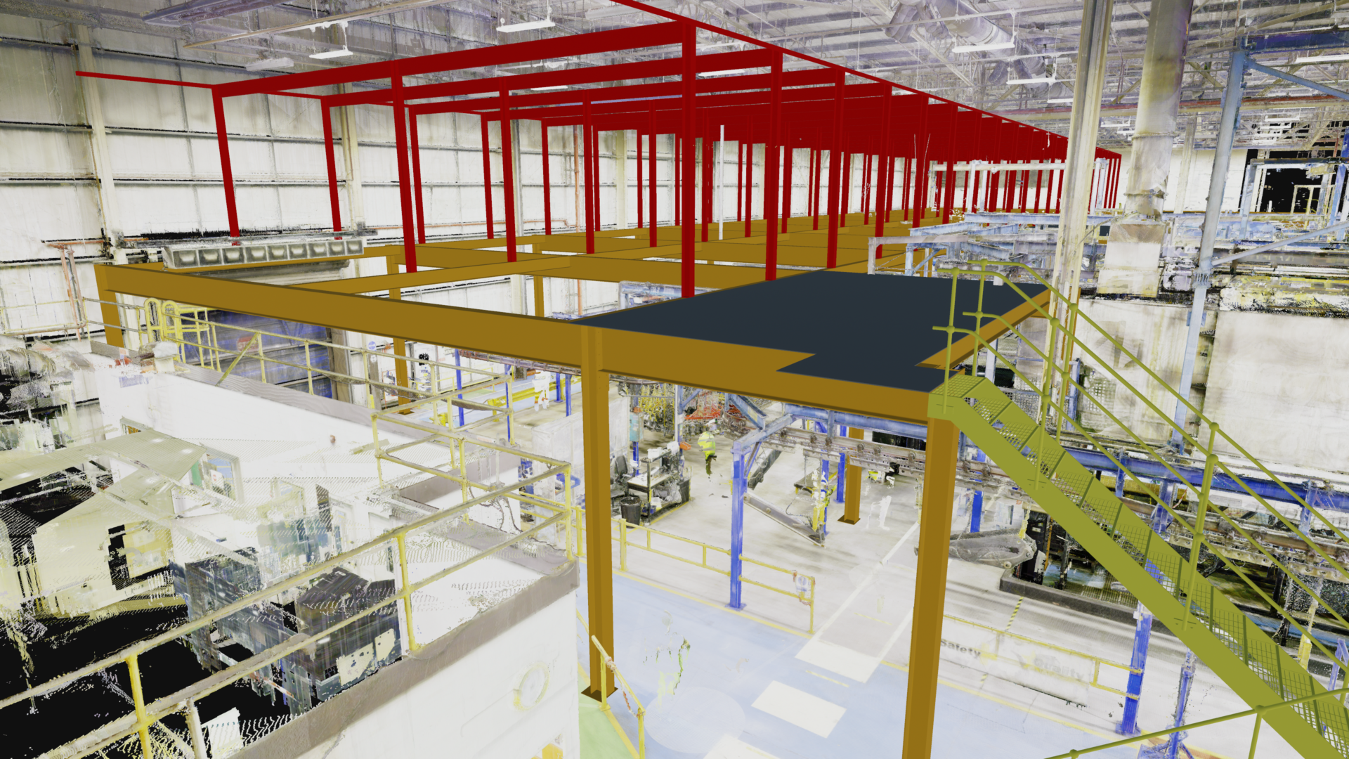
For example, an equipment installation project might require accurate CAD geometry for the floor, supporting steelwork, connection points and nearby pipework. The wider factory or process area could remain as point-cloud data, providing spatial context without the cost of modelling every item.
The proposed design can then be viewed alongside both the selectively modelled existing geometry and the original survey data.
The point cloud can also provide a valuable reference for checking proposed designs against existing site conditions. Potential conflicts with structures, equipment or services can be identified without first having to model the entire surrounding facility.
This targeted approach concentrates modelling effort where it creates value.
Think about who else could use the information
Laser scanning is often commissioned against the budget and requirements of a particular project. Understandably, the deliverables tend to reflect the needs of that project.
However, before deciding the scope, it can be worth considering whether other teams within the organisation could benefit from the same information.
A relatively small extension to the deliverables may sometimes turn a project-specific survey into a useful resource for subsequent engineering, maintenance or planning activities.
That won’t always be justified. Sometimes the immediate project really does only need the registered point cloud. On other occasions, creating appropriate drawings or an as-built model while the survey information is already available can provide considerably greater long-term value.
The important thing is to make that decision deliberately.
Choosing the right deliverables
The most appropriate laser scanning deliverable is therefore rarely determined by the scanner itself.
It is determined by what you need to achieve with the information.
A FEED study may initially need an accurate point cloud. A detailed modification may require selective modelling of critical interfaces. A factory-layout project may benefit from a relatively simple model and 2D floor plans. An asset owner may see value in creating a more reusable as-built engineering resource.
And sometimes the best solution is a combination of all of these.
At Offset Services, we provide laser scanning surveys together with registered point clouds, 2D drawings, purpose-built as-built CAD models and web-based SmartPanoramics. By understanding the intended application before the survey begins, we can plan both the data capture and deliverables around the information that will actually be needed, concentrating effort where it provides the greatest value – both for the immediate project and, where appropriate, for the longer term.